Friday 25 May 2012

The Sacred Valley

We had an extra day in Cuzco before we were continuing our Peruvian trip. In the end we decided to spend this day out of Cuzco and instead visit the Sacred Valley. We found a very cheap bus tour that would take us around to some of the most interesting places in the valley. We were first not sure whether we were being cheated such that there wouldn't be any bus tour at all since it was so cheap, but then we found out that the ticket didn't include any entrance fees to any of the sites along the tour. These entrance fees cost three times as much as the bus tour, but it was still well worth it. 

If we would have stayed in Cuzco, we would have visited the "Sexy Woman" (Sacsayhuaman). Unfortunately, we missed this now, but the bus did pass by the old ruins so at least we got a quick look. 

We saw many football pitches all over Peru, here is one in the Sacred valley. It would have been interesting to try and play at this high altitude. When you just walk around where it is flat, you don't feel any difference from how it is at sea level. However, the heart starts pounding and the breathing speeds up as soon as you start running or walk up steep hills or stairs. 

The altitude definitely makes a difference. There are even FIFA regulations for at how high altitudes World Cup qualifying matches can be played. The limit is at 3000 m, which is a bit lower than Cuzco. The home stadium of the Peruvian national team is in Lima, at sea level, so there are no problems. The home stadium of the national team of Bolivia (Peru's neighbour), on the other hand, is in La Paz, which is located close to Lake Titicaca in the Bolivian mountains at an elevation of about 3650 m above sea level. This is above the limit, but FIFA gave a special exemption for the stadium. The high altitude have helped the Bolivians to some really good results in history. In 1993 they became the first team to ever beat Brazil in a World Cup qualification match and in 2009 they beat Argentina 6-1, which was Argentina's worst defeat in 60 years.


The first stop on the tour gave some nice photo opportunities of the Sacred valley with the Urubamba river.


The second stop was in a small market, where they sold a lot of traditional Peruvian souvenirs. For some reason I never bought a warm hat in Brazil and never brought one over either, instead I bought one here, so that I would be prepared for the colder parts of the trip that were still to come.

Serpentine roads up to the Pisaq ruins.

Terraces in front of the Pisaq ruins.

Some of the Pisaq ruins.

Football pitch in a tiny community, visible from the ruins.


We continued to a market in Pisaq. The market was really big and they had a lot of things, but unfortunately we didn't have much time. That's the disadvantage with these bus tours: you don't have much time anywhere. It's always 30 min here 40 min there, but on the other hand, you do get to see a lot of different things. We then continued to have lunch in Urubamba, where this parrot was sitting just outside the restaurant.

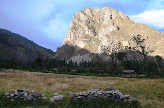
These ruins are in Ollantaytambo. 

The Incas moved these massive stone blocks from across the valley and placed them perfectly next to each other. The fact that they managed to move so enormous stone blocks quite large distances might not be as impressive as what the Egyptians did with the pyramids, but it's still really impressive. I find it even more impressive how they shaped the blocks to perfectly fit together. We will see more of this later, in other old Inca ruins.

The ruins on the right are located a bit up on a mountain in Ollantaytambo. They are situated in the corner of some valleys, such that it is very often windy and cold up there. This might first sound strange, but they were not used as temples or as a military post, but as a big storage houses or as a huge fridge. This way the Incas could keep the food fresh for much longer. To the left in picture you can also see a big face in the rock. I think I heard that it is almost 150 m from top till bottom. The face was carved out of the mountain by the Incas.

The face you can see here in profile is supposedly natural. The time of year when the sun comes up in a certain part of the face marks the best time to sow new crops. 

We found plenty of cacti with many fruits in the ruins, but we didn't yet know what we could do with them...


The Incas formed channels in the stone in order to guide the water to where they wanted it, here into a water temple.

I saw this mountain from the bus close to Ollantaytambo. I think it really looks like an octopus.

The last stop before coming back to Cuzco was Chinchero. There was an old church and many people selling different Peruvian clothes. There seemed to be really good things here for a quite low price, possibly due to that it was a very small community or thanks to that it was getting rather late and it was the last chance for the vendors to sell their goods for the day. Either way, we would have liked to stay longer, but we had to get back on the bus. 

It's amazing how many stars you can see in places like this where you are far from cities and lights and also at a high altitude. I heard some people say that they finally understood why it's called the Milky Way, since you really can see that most stars are along one line.

Thursday 24 May 2012

Cuzco

Cuzco is an old Inca city. It was founded before the Inca times and was made capital of the Inca Empire. It was built to resemble a Puma, where the head is formed by a place called Sacsayhuaman on the northern outskirts of the city. This place was an important military point during the wars against the Spanish. It also contained some temples, including a lightning temple, which forms the teeth of the Puma. English speaking tourists seem to remember the place due to its name, which can be pronounced as "Sexy woman".

The Incas spoke quechua, and since this was a spoken language and not written, many of the names are nowadays spelled in different ways in different places. Cuzco can for example also be spelled Cusco. We also saw the "Sexy woman" being spelled many different ways. The most interesting about this is that the Incas might not even have been called Incas, but rather Enkas, Ingas or something similar. On the other hand, there were actually only very few Incas. It was only the rulers who were called Incas and therefore only about a dozen people have ever really been known as Incas. 


Picture of the Municipal palace in plaza Regocijo. The flag at the top of the building (also shown in the picture below to the left) can be mistaken for the gay flag, but is the flag of Cuzco. The picture below to the right is of a statue in the middle of Plaza de Armas.


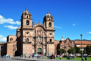
The Cathedral is located on the Plaza de Armas. It contains many artifacts, for example a cross that was brought over from Europe by the Spaniards when they were conquering the Peruvians and "convincing" them to become Christian. It also contains the Black Christ, which is a wooden crucifix that has turned black from many years of exposure to candle light. It is also called the Lord of earthquakes after an image of Christ supposedly stopped an earthquake from devastating Cuzco in the middle of the 17th century.

The church of la compania de Jesus - the society of Jesus, also located on the Plaza de Armas.

Plaza de Armas 

 I'm not called Calle, but there was a Swedish street just off the Plaza del Armas.


Coricancha (or Qorikancha) was an important temple during Inca times. Many of the walls and floors were covered in solid gold and there were many gold statues in the courtyard before the Spanish arrived. They demolished the temple and instead built a church on top of the old Inca temple, keeping some of the foundations. Earthquakes have damaged the church, which has been rebuilt, but the Inca foundation still stands.


Cuzco is located about 3400 m above sea level. If you are not accustomed to high altitudes, it is therefore recommended to adjust to the altitude before doing anything else. Instead of immediately exploring the city, we therefore relaxed for a while in the hotel. We read a book and drank some tea. This was a very common and popular tea in Peru: coca tea, which is used to prevent altitude sickness. It is made by submerging leaves of the coca plant in hot water. Yes, that is the same plant as is used to make for example cocaine. However,  the concentration is very low without any enhancing chemical processes.


All of Peru seem to be very environmentally friendly. We saw many signs telling people to turn off lights and to save water. They also sort their thrash into organic and inorganic waste. The picture below is taken in our hotel room in Cuzco. 

The highest Irish-owned pub, Paddy's, is located in Cuzco.

Wednesday 23 May 2012

Lima

Our first stop in Peru was the capital, Lima. Lima is a big city with a population of about 8 million and is located along the beach of the Pacific Ocean. 


These two pictures are from the Parque del Amor - the Love Park - which is located a stone's throw from the beach.


Almost all traffic signals had a counter so that you knew how long time you had to cross the street. However, this didn't stop most cars from beeping all the time.
There were instruments measuring the UV-radiation along the beach in Lima. This was pretty good to remind you to use sunscreen and to use one with a high enough protection factor. 


The government house, which was located on the Plaza de Armas.


Francisco Pizarro, the Spaniard who conquered the Incan Empire and founded Lima, is buried in the Cathedral in Lima. The picture above shows the Plaza de Armas with the cathedral and some of the yellow buildings that surround most of the square. The pictures below show Pizarro's tomb and the opposite wall. The walls are covered with small tiles that form the paintings you can see on the walls.


The picture below to the left is from inside the cathedral, whereas the one on the right is of the monastery of San Francisco. As you can see, it's a favorite spot for many of the local birds.

 We were often reminded about where we were going later in the trip.

Tuesday 22 May 2012

There and back again...

I'm now back from one of the best trips ever and I will write much more about it in the coming posts. It all started with a flight to Sao Paulo, which almost felt like it could have been my last flight ever. The plane was shaking quite a bit and was making a lot of loud strange noises. Many of the people aboard were praying for their lives. The most interesting part was when the noise stopped for a short while, since it stopped at the same time as we entered some turbulence and the plane started to loose altitude. In the end everything was fine, but after Sao Paulo the plane was supposed to continue to Paris, a flight I'm happy I wasn't on.

We then continued to Peru where we had a wonderful time. We normally book all flights, hotels and everything ourselves, without using a travel agency. However, this time we thought it would be easier to get help from a big agency. We just went in to one and asked if they could create a package with everything we wanted. It worked extremely well. It was so easy and nice to have everything organised and never having to care about transfers or having to check bus times and so on. If there was anything planned for the next day, we received a message in the reception the afternoon/evening before with the time they would pick us up in the lobby of the hotel. 

The funny thing about this though, was that we were not listed by our names as normally in hotels. We were not listed by a reference number either. Instead, we were listed as "Camino Inca y Lago", since that's what the travel agency called our booking. It took a while before we realised this in the first hotel and could check in, but afterwards everything was fine. It was pretty funny in the airports when the drivers, who would transfer us to the hotels, had signs with a few normal names and "Camino Inca y Lago".

Of course things happened on the return trip as well, so that it wasn't as smooth as it could have been. We first had a flight from Juliaca to Lima, then Lima to Sao Paulo and finally Sao Paulo to Belo Horizonte. For some reason it wasn't possible to have our bags transferred all the way, but we had to take out our bags at every step and check in again. However, the people who checked in at the desk next to ours were on the same first two flights as us and for them there was no problem having the bags transferred all the way to Sao Paulo.

In Sao Paulo they have a counter only for people with connection flights, which is supposed to speed up things a bit, even though every one who are connecting to domestic flights have to take out their bags and check in again. Of course there was long queue before us and when we finally arrived there we were told that we were too early to check in the bags. First we got a bit annoyed, but then we were able to transfer to an earlier flight, so everything turned out quite well in the end.

Tuesday 8 May 2012

Ilha Grande - day 4

We went for some trekking through the forest on the last day as well. This day we passed a natural pool and a waterfall on the way to Saco do Ceu, which is not another beach, but a bay with a small village. 

 Another picture of the bay of Abraao. 

 A natural pool.

There is a nice view of Enseada das Estrelas along the path.

Cachoeira da Feiticeira. 
I was jumping around on the stones, trying to see everything. Some of the stones turned out to be quite wet and slippery, which might not be so surprising next to a waterfall. I ended up falling anyway, while carrying my camera. All I was thinking during the fall was to not get the camera into the water and I realised what an idiot I was. Somehow I managed to save the camera and not get injured, so it wasn't too bad.

There were many beaches on the way, praia da Feiticeira, praia da Camiranga, praia de Pereque, praia de Fora, praia do Galo and praia do Conrado. They were all nice, but not incredibly amazing, so since I already put so many pictures I won't put pictures of these beaches. I also don't actually remember which beach was which, but it doesn't matter too much.

We got a visit from a big cruiser. 

Even in a small fisherman's village along the way, we found a football pitch. It might be a bit difficult to see, but there is a fishnet hanging all over the football pitch. We had to walk back the same way we came, and when we walked past the pitch on the way back the fishnet was down, so the football could start again.

The most common way to get around the island was by boat. I already mentioned that the roads between villages were only made for walking (even cycling would be very tricky). However, if you are rich and in a hurry you can also take a helicopter.

Sometimes the clouds came quite far down, which looks pretty cool.


Saco do Ceu

The tide had come in during our time in Saco do Ceu, which left some of the beaches we walked across earlier in the day submerged. We therefore had to take off our shoes three times on the way back. We kept putting them back on since the track was full of stones and tree branches. The bad part was that since we didn't think we would have to remove the shoes all the time, we cleaned our feet as good as possible in order to remove the sand, which otherwise might leave blisters on our feet. The worst part was that we found that we could have walked another path and completely avoided the sea and all the fight with the sand and the shoes, which actually did become a bit annoying after a few times.

There was a Finnish ice cream shop in Abraao. Unfortunately, it was being refurbished  when we were there.

There was a three dimensional map of Ilha Grande in a tourist information.